


Sports, recreation and physical activity cluster
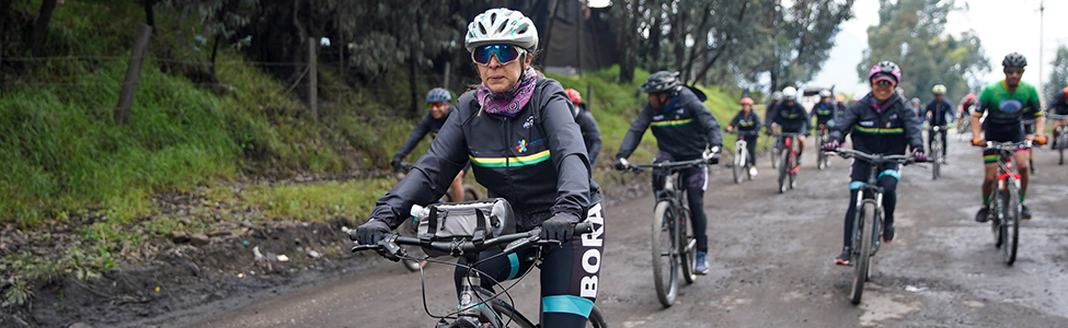
Pedaling through Cundinamarca

How can we help you?


We want to improve your experience
Your experience inspires us to improve. Please rate our website using the following survey.
If you wish to make a request, petition or suggestion, you can do so through our SPQyF system and contact us:

Turmequé Route
Villapinzón – Turmequé - Villapinzón

Level of complexity: ◉◉◉◎◎

This 48.7 kilometer route travels along the paths of the glorious past of the Muisca chiefs, who as part of their sacred rituals used a kind of gold discs called "zepguagoscua" that they offered as an offering to their gods. Later they were used to apply justice, to win the love of the beloved woman, to settle conflicts, or for simple amusement, which is how we know today the popular practice of Tejo or Turmequé.
The town of Villapinzón is 80 kilometers from Bogotá, where the Bogotá River rises in the Paramo de Guacheneque. There, among mosses and frailejones, a timid riverbed opens its way to form the first bodies of water. First the Laguna de Guacheneque and later the Laguna del Mapa, named for its resemblance to the sketch of Colombia. Later on, it is strengthened by the water of other small rivers until it forms a 17-meter waterfall known as the Otter, and it is at this point that the Funza or Bogotá River takes shape and begins its journey through 47 municipalities until it flows into the Magdalena River in Girardot. Well, in the Main Park of Villapinzón begins this journey. There, with the frame of more than a dozen traditional houses and some pines and willows, we will find the Casona de la Alcaldía and the San Juan Bautista Church, both of great architectural and cultural attraction for the town. From this point we will take Carrera 5 to the traffic circle that separates the roads to Tunja, Umbita and Turmequé. This last exit will lead us for about 20 kilometers on an unpaved road to Turmequé, passing through the villages of La Merced, Chasquez and Bosavita, in the jurisdiction of Villapinzón; and Guanzaque, Chirata and Jurata, in Turmequé. The greatest difficulty of this route will be found in the section between kilometers 3.3 and 5.4 when we face a small ascent with slopes ranging between 4 and 8%, which, taking into account the unpaved terrain, represent a great demand for cyclists. Also on this stretch you can find several places to stop, rest and eat. Some of them are the Rodadero Campestre restaurant, Oasis Bakery and Arepas Xiomy, located at kilometers 7.4, 13.8 and 19.2 respectively. Upon reaching Turmequé, after completing the 20 kilometers, we will walk through some of its streets until we reach the main park, where the monument to the cacique Turmequé stands, which evokes the genesis of tejo, the region's flagship sport. It was designed and built by the Boyacan artist Omar Santamaría, using the scrap metal technique.
Next to the park is the Nuestra Señora del Rosario Church or the Latin American Sistine Chapel, as it is also known for its mural painting that dates back to the 17th century and was only discovered in 1988 when part of the wall covering accidentally fell off, exposing part of the painting of the Archangel Saint Michael. Work was then begun to finish uncovering the paintings that were hidden in the walls and to try to restore them. Right there, in the sector of the main park, you will find diverse gastronomic alternatives, most of them of traditional cuisine. Some of them are Las Delicias del Cacique, Cacique Turmequé and Legend Casagrande Turmequé, the latter two with additional lodging services. Finally, the return to Villapinzón to complete the 48.7 kilometers of the route will be by the same route. However, this time with an important peak that stands out in the route. We will find it at kilometer 26 and it will extend for 8 kilometers more. It includes a very hard climb that in only two kilometers goes from 2% to 15% of inclination, continues with slopes that remain between 6 and 7% followed by a brief descent and ends with three kilometers of constant ascent with an average slope of 6% of inclination. On your way back to Villapinzón you can pass by the Piqueteadero Doña Rufina Restaurant, El Almendro Restaurant or La Terraza Gourmet Restaurant, all with a very tasty offer of Creole food.
Flying goal:
In the moors of Villapinzón, several spectacled bears used to live there. That is why, in memory of them, the double waterfall that springs from the Laguna del Valle, was named El Pozo del Oso (The Bear's Well). And to a stone, hollow inside, which evokes the face of these animals, they called it the Bear Cave. This natural paradise, adorned with a varied flora such as the Frailejón, the Enecillo, the Agrás de Monte, the Cardón Santo, the Guaque, among others, is a jewel for ecotourism and contemplative tourism.
Was this content useful to you?


Share it on:


